


SBC: Before the Flood
North Yorks Enquirer Harbours correspondent has been examining fresh discrepancies emerging in Scarborough Borough Council’s application of Flood Risk Zone regulations in regard to the universally disliked West Pier ‘regeneration’ project.
~~~~~
How strange that there is an apparent difference in interpretation of the way building developments in areas of acknowledged flood zones are considered by the SBC Planning Department.
The Government web site provides a map to aid planners, showing a colour-coded key to identify the various risk of flooding in different areas:
In a recent planning application for the construction of a café and external paved seating-area, on a site known as ‘the bulge’ along North Bay Promenade (marked in red on the map), the area was described by SBC Planners thus:
“Planning officers said the proposed café is in an area that is known to be frequently affected by waves over–topping from surges and strong winds and has a high risk of flooding, and was therefore not suitable.”
[Scarborough News, 2nd March 2022]
However, a visit to the ‘Flood Risk Map’ reveals the proposed ‘bulge café’ to be completely within an area marked in Light Blue in the colour-code, and is thus designated ‘Low Risk’.

Four days later, in a different Planning Application, this time to build a first-floor extension to an existing café on East Pier (marked in red on the map), SBC Planners accepted that are, stating:
“There is no or very low risk of flooding in the area”.
[Scarborough News – 6th March 2023]
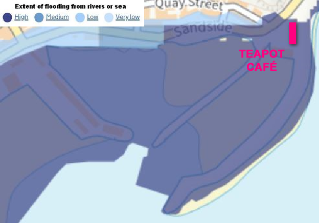
Strangely, a visit to the ‘Flood Risk Map’ shows the proposed extension on East Pier to be in an area marked Dark Blue, thus ‘High Risk’ – as is Vincent Pier and West Pier.
Let me say, at this point, that I have no axe to grind with either of these proposals, indeed I do occasionally use the popular, and locally owned Tea Pot Café on East Pier, and of course both proposals are from private individuals risking their own financial investment.
Fair play to them both.
I wonder, though, are the SBC Planners colour blind?
Or is it that they are expecting another planning application in the near future, that is also within the area considered to be ‘High Risk’, according to the ‘Flood Risk Map’?
I refer of course to the West Pier Regeneration Plan, which is not privately funded, but is funded to the tune of £11.5m, by the taxpayer.
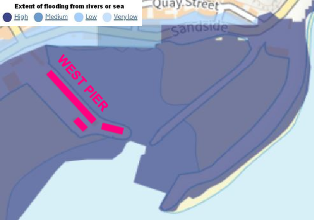
A Flood Risk Assessment provided by the Environment Agency in consultation with SBC’s Coastal Team (dated November 2021), confirms that:
“That West Pier floods on a broadly annual basis and is currently managed with the use of warnings and sandbags.
That the pier walls do not provide an adequate level of tidal flood protection and that the pier already experiences frequent flooding.”
Not only is West Pier in a ‘High Risk’ area (which “floods on a broadly annual basis”), but the plans are to LOWER the ground level of the new buildings (marked in red on the map).
The site is located in an area which is within higher Flood Risk categories and the Council’s Coastal & Drainage Engineer has confirmed that the site has been inundated by the sea in the past. It is mainly within Flood Risk Zone 2, with a smallarea at the front being in the highest Flood Risk Zone 3b, as defined by the Council’s Strategic Flood Risk Assessment.
As such, the development fails to comply with the requirements of Policy ENV 3 of the Scarborough Borough Local Plan, and poses a High Flood Risk – and is therefore unacceptable.
Paragraph 162 of the Framework states:
“Development should not be allocated or permitted if there are reasonably available sites appropriate for the proposed development in areas with a lower risk of flooding.”
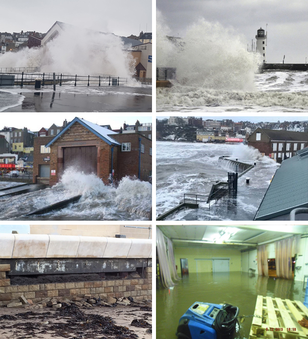
When one considers these images of flooding on West Pier and the surrounds of the harbour, then I suggest the Planners are wearing rose-tinted spectacles when considering the risks on West Pier.
[youtube id=”imrrR_V2KCQ” width=”620″ height=”360″] [youtube id=”RYKrzqPRliE” width=”620″ height=”360″]


